
All of my friends know for a fact that I love snow. Whenever I hear about snow on the news I am the first to be on all of the weather sites keeping myself up to date with amounts and cold temperatures.
One blog in particular that I like to keep up with is our local weather man here in Louisville, John Belski. He’s always the first person to be on top of weather updates and how much we can expect in the area. He shares photos of the GFS, Euro, and NAM models. I can’t really tell you the meaning behind those names, other than that they show different snow totals. Usually they never really show a whole lot of snow. For example here is what the GFS model looks like…
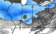
Every time I saw this on the radar I would speculate that the snow would miss us. The snow models that really caught my eye were the Canadians. They look a little something like this…

The canadian model shows at least 6-10 inches of snow. How they comes up with these totals I have no clue, but it’s really awesome to look at and speculate. According to Belski’s blog, we won’t be seeing this snow until Wednesday. A second system is expected to come the following day so we will see how this turns out.
In the meantime, I’m going to sip on my coffee and try to keep warm as these cold fronts make their way on in.
~ Keep it all smiles

Leave a comment